Most people, almost instinctively, recognise medieval villages, towns, cities and their roads from their characteristic irregular appearance.
It is understandable that the bloke down the pub might think this, but it is inconceivable that most modern historians do.
What these ‘medieval’ settlements and their road system actually represent, I believe, are the remains of much earlier settlements – prehistoric, certainly older than Roman.
I believe that it is the unexpected way in which Roman roads relate to these so called medieval roads shows that theses ‘medieval’ roads must have been built long before the Roman roads.
I hope I can show this with various examples.
Much of present day south London
is built on low-lying ground but originally it was marshes, salt marshes in
fact. However, in this area there are a number of natural gravel ‘islands’
and these would have been the most likely places to be permanently settled.
These gravel islands have indeed been settled - by medieval type villages
like Kennington, Rotherhithe, etc. What is equally clear is these villages
are connected by a ‘medieval’ system of ‘country lanes’
or roads, characterised by their irregular and winding routes. They are clearly
ancient but how old are they? They share something else in common, they were
either built on higher ground, or the ground has been artificially raised
under them – to produce causeways. A good example is Newington Causeway.
These have to represent a considerable amount of work given the amount earth
that must have been moved to build them. It seems very likely that they must
have been built before the marshes were fully drained, this would suggest
an early date
Because there are Roman roads in this area it should be easy to find out if
this ‘medieval’ road system existed before or after the Roman
roads.
These two idealised diagrams show why

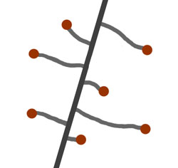
The image on the left shows a straight road as it would appear if it was built later than the existing local roads. The image on the right shows the likely development of local roads if a fast straight road had already been in place.
The red dots represent the villages – the settlements, and they are the same in both diagrams as their positions are fixed by the gravel ‘islands’. Notice how the two road systems are completely different.
I want to look in detail at Kennington Lane, it is one of those old meandering country lanes that has somehow survived the total urbanisation of this area. It is the old road that connected Kennington, an ancient village built on one of the gravel ‘islands’, and Vauxhall or south Lambeth as it is also known. Vauxhall is not on high ground however, it is at the mouth of the river Efra and the creek here would have formed a natural harbour. No trace of it remains today but it must have been very similar to Deptford Creek and can be thought of as a 'mini docklands' and has probably been used like this ever since the Thames was first used by traders, which must be very early indeed. There is of course archaeological evidence that something important was going on here before the Roman period.
There is not much high ground,
if any, between the ancient village of Kennington and Vauxhall and this means
that all of Kennington Lane must have been built on marshes and is in fact
a causeway, a great deal of earth has been used in its construction as it
is noticeably raised. This can easily be seen where the eighteenth century
Kennington Road crosses it (see below). It is much higher than the Georgian
road which presumably did not need to be raised because by then the marshes
were drained. It’s not difficult to see that because of the length of
the lane a considerable amount of work would have been required to build it
and because of this I would expect it to take the shortest possible route.
If the well-built Roman road was already in place then I would have expected
the lane to have been built from Vauxhall to pick up the Roman road at the
present day Oval, such a road would be less than half the length of Kennington
Lane - a considerable saving of effort.

Kennington lane is in turquoise, the Roman Kennington Park
Road is in blue
There is something odd about Kennington
Lane, the section that the eighteenth century road crosses is roughly parallel
to the Roman road, I find this very unexpected if the Roman road was already
in place as if this stretch of road had been built a right angles to its present
course then it would have met the Roman road at Kennington Common, again a
considerable short cut. To be fair, the reason the lane behaves like this
here is that it is probably following a small tributary of the river Efra,
but once this obstacle is out of the way I would expect it to make a beeline
for the Roman road meeting it with an emphatic ‘T’ junction. It
doesn’t do this, instead it continues for a considerable way at an oblique
angle to the Roman road before finally meeting the Roman road at a very strange
angle
In Kennington there is an
eighteenth century new road, Kennington Road and it is dead straight, just
like a Roman road (which probably inspired it). It cuts through Kennington
Lane. This is not unexpected as the road is far more recent than the medieval
period. It looks just like the first diagram.
Where older irregular roads are cut obliquely by a new straight road you get distinct wedge shapes at the junctions. What is unusual about these shapes is that they are dead straight on one side - because of the straight newer road, but curving on the other older side.
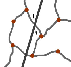
This shows how the wedge shapes are formed
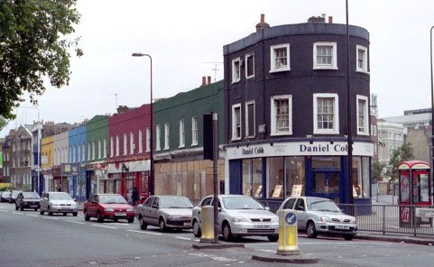
This is a wonderful group of shops built on the ‘wedge’
created by the Georgian scheme in Kennington, this is a view of the straight
side.
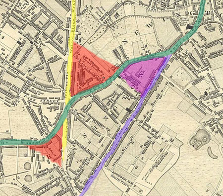
Here it is again as the lower red wedge, and its corresponding wedge above,
part of the eighteenth century scheme. The Georgian road is shown in yellow.
Further along Kennington Lane is another of these distinctive wedge shapes
marked in purple, this is the shape that Kennington Lane and the Roman road
make as discussed above, flat on one side, curving on the other.This unusal
shape can only mean one thing - that the Roman road must have been built after
the supposedly medieval Kenington Lane
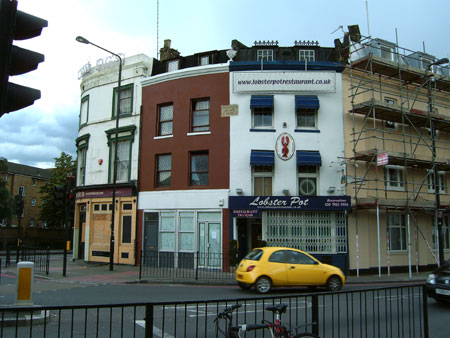
These are the buildings on the Kennington Lane/Road junction,
the Roman road is behind the disused pub on the left. There have been buildings
on this site since at least the beggining of the eighteenth century.
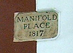
This is a close-up of the plaque between the two central buildings
There is another piece of evidence here, the Roman Kennington Park Road, if
it was built on a causeway it is so low as to be practically non-existant
and is in marked contrast to Kennington Lane which is obviously raised. This
strongly suggests that by the time the Roman road was built the marshes were
already relatively well drained.
home
| missing Roman road | The
real Troy discovered | pre-Roman London
| Britain's forbidden history | contact
the author